This watershed is situated in the northern half of the old Kensington school district, the southern two thirds of Indian River, the southwestern quarter of Baltic together with small part of western Margate. The highest elevations of 54 m are found in Kensington and in Margate east of the Irishtown Rd (Rte 101). The land slopes northward in the southern half and westward in the northern half of the watershed towards Malpeque Bay.
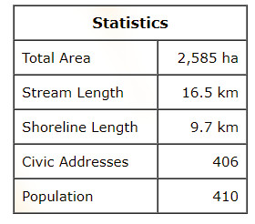
The source of the Indian River is a seasonal wetland east of Broadway St. North in Kensington. The river flows in a northerly direction and crosses Route 20 three times over its 7.3 km length before draining into the Indian River Pond. A fish ladder at the head of tide provides access to the pond for trout, smelts, and gaspereaux during seasonal migrations. A branch roughly 2.0 km long flows west from the west side of the Irishtown Rd (Rte 101) into main river east of the Murphy Rd while a second branch about 1.8 km long flows north along the east side Clermont Rd (Rte 106).
This watershed also includes the north half of Mills Point west of the Clermont Rd (Rte 106) and generally north of the Mills Point Rd. There are no streams in this area but run-off flows northward into the Indian River estuary and Malpeque Bay.
The watershed is also home to the Indian River Wildlife Management which surrounds the Indian River Pond.