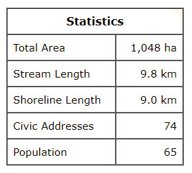
This watershed is situated in the northern two-thirds of Park Corner along with parts of Irishtown and Long River. The highest elevations of 86 to 100 m are found in the southwest corner of the area east of the Campbell Rd. The land generally slopes northward to the Gulf of St. Lawrence.
The Campbells Pond system starts in the hills between the Irishtown Rd (Rte 101) and the Long River Rd (Rte 262). It flows generally northward for about 3.5 km from the steeply sloped woodland, under the Long River Rd, though farmland and woodland, and drains into the Lake of Shining Waters before it flows under Rte 20 into Campbells Pond and finally into the Gulf of St. Lawrence. A number of tributaries totalling 2.9 km in length enter the system over its length. The first pond is about 0.5 km long covering about 2.7 ha, while the main pond almost 0.8 km long and covers 13.4 ha.
At the east end of the area, a second stream about 1.6 km long flows southeast parallel to the French River and passes through Simms Pond before entering New London Bay. Additional shoreline-direct drainage totalling 0.5 km lies east of Campbells Pond.